Best digital land survey in Bangladesh

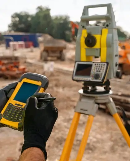
A digital land survey is a contemporary approach to land measurement and its representation on a map. It applies various devices such as Global Positioning Systems (GPS), unmanned aerial vehicles (UAVs), laser beam projectors, and computers to obtain precise information about a given area of land. Barnomala Architects & Interior provides the best digital land survey in Bangladesh.

Are you looking for reliable land survey services in Bangladesh? We use advanced technologies and professionally qualified surveyors to take and record all the necessary measurements accurately. Whether you buy land, construct a building, or need the survey for legal matters, we provide accurate results that you can trust and rely on.

Are you prepared to start with your digital land survey? We are ready to assist. Call us at +8801713776555 for a free estimate. Our specialists are always eager to respond to your inquiries.

Get A Quotation

Dot Shape Digital land survey in Bangladesh

Why digital land survey is important?

Conventional survey forms may take a long time to assess the land and could still be inaccurate. On the other hand with digital surveys, there are modern devices that are used to gather Information which is very specific. It ensures that all the measurements and even the boundaries are accurate. Costs and errors are in most cases associated with traditional surveys.

Whereas in digital surveys, tools like drones and GPS are used to acquire information which is highly accurate. It also aids in the production of clear and accurate maps of the land area. For instance, with respect to digital surveys, borders and measurements are guaranteed to be correct which helps to eliminate the possibility of any conflicts in the future.

Call us: +8801713776555

Digital land survey process of Barnomala Architects & Interior

The process of digital land survey is straightforward and efficient. To begin with, we sit down with the client to find out the requirements. We utilize advanced technology like GPS and drones in order to record factual information concerning the land. Here is the process:

  • Initial consultation
  • Land inspection
  • Researching
  • Assessing
  • Preparing a report
  • Evaluation of customer
Digital land Survey Process

Benefits of digital land surveys

Like any traditional land surveys, modern ones such as digital land surveys make for highly accurate and precise measurements. It gives comprehensive details of the land including its measurements, limits, and features among other things. Here are some benefits of digital surveys:

  • High accuracy
  • Time-saving
  • Advanced technology
  • Cost-effective
  • Detailed data
  • Improved planning
  • Legal support
  • Eco-friendly
Contact us Now

Uses of digital land surveys

Digital land surveys have many uses. It helps to understand the correct boundaries of land so that disputes can be avoided. These surveys are of utmost importance when buying property, selling it, and even preparing legal documents. It is utilized in construction projects to design structures, such as buildings, roads, and even bridges.

These are highly used by governments for land administration, planning of cities, and taxation purposes. It also helps in environmental studies for example in mapping areas prone to floods or managing catastrophes. With the right information and a high level of technology, digital land surveys reduce risks and make decisions concerning land issues more efficient.

Call us: +8801713776555
Uses of digital land surveys

Why choose Barnomala Architects & Interior for digital land survey?

For digital land surveys in Bangladesh, Barnomala Architects & Interior is the ultimate solution. We embrace modern tools like GPS and drones to ensure high accuracy. Our team is highly qualified and deals with all properties. Our services are prompt and we meet all deadlines on time.

Here are some reasons behind choosing us:

  • Results with high accuracy
  • Well trained experts
  • Quick and efficient service
  • Cost effective rates
  • Nationwide coverage
  • Legally accepted documents
  • Modern tools and technology
  • Custom solutions
  • Trusted institutions
  • Excellent customer support
Contact us Now

Frequently Asked Questions

In digital surveys, several modern approaches and instruments are employed to quicken the whole process. It increases the precision level of the outcomes.

The price will differ depending on the size and the type of the area. For this reason, you can always contact us for a free price estimate with no obligations.

Surveys are usually accomplished within two or three days. However, larger or more complex properties may take slightly longer.

The precision of the survey is achieved by the use of such advanced tools as GPS, drones, and laser equipment.

Sure, you will receive a thorough report with maps, dimensions, and any other relevant details about your site.
Let’s Get in Touch
Need interior design solutions?

Get free estimation about your project! Feel free to call or contact us.

Arrow